Located within the district of Uttarkashi and connected with a network of numerous strongly built roads, Gangotri Dham is one of the most easily reachable Chardham Yatra destinations in Uttarakhand. This Dham is located at a distance of 300 km from Dehradun, 250 km from Rishikesh and 105 km from Uttarkashi. Here is the best route for you to visit and how you can reach the temple in the most convenient and hassle-free manner:
By Road
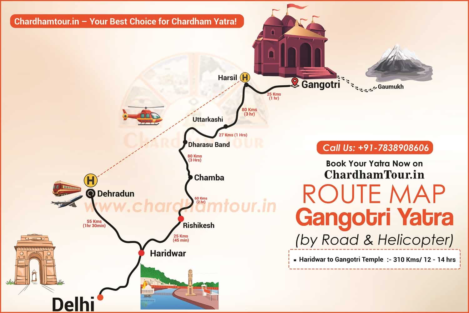
Reaching Gangotri Dham via a road journey is an easy task and the entire journey will drop you off right near the entrance of the temple. These roads are also well connected to some of the major cities as well as the minor nearby towns and cities. No matter which part of India you are planning on making this trip from you will first of all be reaching till Haridwar / Rishikesh of the Gateway to Chardham. Here is a brief route map of Gangotri from different places in India:
Haridwar to Gangotri Temple Route Map
Total Distance: 310 km | Total Time: 12–14 hours
Haridwar 🚗──25 Km/1 Hr──▶ Rishikesh 🚗──60 Km/2 Hrs──▶ Chamba 🚗──80 Km/3 Hrs──▶ Dharasu Band 🚗──27 Km/1 Hr──▶ Uttarkashi 🚗──80 Km/3 Hrs──▶ Harsil 🚗──25 Km/1 Hr──▶ Gangotri Temple 🛕
- From Chennai: Chennai – Delhi – Haridwar – Rishikesh – Chamba – Dharasu – Harsil – Dharali – Gangotri
- From Nainital: Nainital – Kashipur – Rishikesh – New Tehri – Uttarkashi – Gangnani – Harsil – Dharali – Gangotri
- From Mussoorie: Mussoorie – Landour – Dharasu – Uttarkashi – Gangnani – Dharali – Gangotri
[Note: Remember that Travelling on the hills shuts down by sundown.]
By Train
The closest railhead for Gangotri Dham is situated at a distance of 249 kms in Rishikesh. People from various parts of India especially from south, can choose the option of either hiring a taxi/cab or a bus service heading for Gangotri. This option of travelling is chosen by a large number of tourists arriving primarily from the southern end. However this railhead is not connected via other fast trains whereas Kotdwar, on the other hand, caters a very few number of trains.
By Air
If you are planning to visit Gangotri Dham from far away then you can take a flight to Jolly Grant airport in Dehradun. This airport is situated at a distance of 279 km which takes almost 8 hours to cover. There are several taxis and cabs available right outside the airport which you can hire and make your way to Gangotri easily. You also have the option of choosing luxury buses services heading for Gangotri.
By Helicopter
Most people choose to travel to Gangotri via a helicopter service, if you have somebody with you who is incapable of completing the Yatra journey on their own. You can also choose this service if you want to have the most luxurious, comfortable and smooth journey. You can also choose to go to Gangotri by helicopter if you are running short on time.
– In this case your journey will commence from Sahastradhara helipad in Dehradun.
– After an hour of flying journey you will be arriving at Harsil helipad. You will be transferred via a cab to the temple where you will be given a priority Darshan.
– After spending a few hours there you will be making your way back to the helipad at Harsil for your journey back to Sahastradhara helipad in Dehradun thus, marking the end of your journey.
Facilities Available En Route
Apart from the obvious and ever-present natural beauty the paths leading up to the main entrance of the temple is lined with various shops, tea stalls, restaurants, hotels, lodges etc. there are shops offering various puja Samagris and other relevant options for the pilgrims to offer inside the temple. The routes leading up to the main temple are narrow but well-built and should definitely be avoided during monsoon months. Also some parts of the roads are broken and driving up these hills requires expert driving skills.
Gangotri to Kedarnath Route Map
Total Distance: 414 km (drive) + 16 km (trek) | Total Time: 16 hours (drive) + 6–8 hours (trek)
Gangotri 🛕🚗──25 Km/1 Hr──▶ Harsil 🚗──80 Km/3 Hr──▶ Uttarkashi 🚗──27 Km/1 Hr──▶ Dharasu Band 🚗──92 Km/3 Hr──▶ Tehri -🚗──90 Km/3 Hr──▶ Srinagar 🚗──33Km/1 Hr──▶ Rudraprayag 🚗──10 Km/20 min──▶ Tilwara🚗──35 Km/2 Hr──▶ Guptkashi 🚗──15 Km/1 hrs──▶Phata -16 Km/1 hrs──▶ Sonprayag 🚗──6 Km/30 min──▶ Gaurikund –↓🥾 116 Kms / 4- 8 hrs Trek- Kedarnath Temple
Step-by-Step Route Breakdown
| Segment | Distance | Time | Mode | Highlights |
| Gangotri → Harsil | 25 km | 1 hour | 🚗 Drive | Bhagirathi River views, pine forests. Apple orchard |
| Harsil → Uttarkashi | 80 km | 3 hours | 🚗 Drive | Visit Vishwanath Temple. |
| Uttarkashi → Dharasu Band | 27 km | 1 hour | 🚗 Drive | Scenic mountain roads. |
| Dharasu Band → Tehri | 92 km | 3 hours | 🚗 Drive | Tehri Lake and dam views. |
| Tehri → Srinagar | 90 km | 3 hours | 🚗 Drive | Alaknanda River valleys. |
| Srinagar → Rudraprayag | 33 km | 1 hour | 🚗 Drive | Confluence of Alaknanda & Mandakini rivers. |
| Rudraprayag → Tilwara | 10 km | 20 minutes | 🚗 Drive | Short drive through hills. |
| Tilwara → Guptkashi | 35 km | 2 hours | 🚗 Drive | Ancient Vishwanath Temple. |
| Guptkashi → Phata | 15 km | 1 hour | 🚗 Drive | Major hotel & helipad area |
| Guptkashi → Sonprayag | 16 km | 1 hour | 🚗 Drive | Last motorable point before Gaurikund. |
| Sonprayag → Gaurikund | 6 km | 30 minutes | 🚗 Drive | Shared jeeps only; trek starts here. |
| Gaurikund → Kedarnath Temple | 16 km | 6–8 hours | 🥾 Trek | Steep trail, ponies/palkis/ Helicopter available. |
Key Travel Tips
- Road Conditions: Mountain roads are narrow and landslide-prone (avoid monsoon: July–September).
- Permits: Registration is mandatory—complete your registration before starting your Yatra for Kedarnath Temple.
- Trek Preparation:
- Wear comfortable shoes 🥾 and carry rainwear.
- Book ponies// Helicopter in advance at Gaurikund.
- Health: Acclimatize to avoid altitude sickness; carry basic medicines.
Major Highlights
- Harshil: Apple orchards and serene Himalayan landscapes.
- Dharali village – winter home of Gangotri – Mukhba village
- Rudraprayag: Sacred confluence of Alaknanda and Mandakini rivers.
- Guptkashi: Ancient Vishwanath Temple.
- Kedarnath Temple: One of the 12 Jyotirlingas, surrounded by snow-capped peaks.
Gangotri Distance Chart from Major Parts of the Country
- Chennai to Gangotri – 2,654 km
- Bangalore to Gangotri – 2,623 km
- Kolkata to Gangotri – 1,938 km
- Kochi to Gangotri – 3,169 km
- Hyderabad to Gangotri – 2,031 km
- Mysore to Gangotri – 2,772 km
- Tiruchirappalli to Gangotri – 2,962 km
- Ahmedabad to Gangotri – 1,443 km
- Indore to Gangotri – 1,335 km
- Vishakhapatnam to Gangotri – 2,225 km
- Mumbai to Gangotri – 1,940 km
- Bhubaneswar to Gangotri – 2,090

 Call
Call WhatsApp
 Enquiry


Leave a Reply